East Texas severe weather updates

Keep up with the latest information below.
TYLER, Texas — When severe or a drastic change in weather makes its way to East Texas, CBS19 is here to keep you informed and safe.
It will be cloudy, blustery and cold Friday with a chance to see morning snow showers or snow flurries. Conditions will improve by afternoon as highs rise to near 40. The wind will be out of the NW at 10-20 mph.
FRIDAY, JANUARY 10
7:20 AM – Carter BloodCare in Longview and Tyler will have a delayed opening of 10 a.m. Friday. Mobile drives have been canceled.
6 AM – Snow flurries coming down in Mount Pleasant around Highway 271 and Interstate 30.

5:45 AM – Ice/snow spotted in Winnsboro at the First National Bank.


5:20 AM – Brownsboro Fire and Rescue reported an electric line down across FM 3204 in the 19000 block. The department has also seen multiple trees down on FM 3204, and they encouraged people to drive slow and watch for any hazards.
4AM – More than 30,000 are without power across East Texas.
THURSDAY, JANUARY 9
4 PM – Some Brookshire’s stores are closing at 8 p.m. Thursday due to wintry weather. The locations include:
- Lindale
- 2020 Roseland Blvd. in Tyler
- 2734 E. Fifth Street in Tyler
- Palestine
- 20100 State Highway 155 in Flint
- 100 Rice Road in Tyler
- Bullard
- Chandler
The stores will reopen at 8 a.m. Friday.
2:30 PM – According to Longview Transit, all Greyhound trips have been canceled Thursday. Longview Transit will operate until conditions become unsafe.
The city of Gilmer offices closed at noon Thursday and will reopen at 10 a.m. Friday. Garbage pickup will not run Friday.
Texas Oncology offices in Tyler, Nacogdoches and Athens will be closed Friday.
City offices in Marshall, including City Hall, municipal court, water billing, convenience station, library, golf course and convention center closed at 1 p.m. Thursday.
The City will continue to monitor the weather and road conditions to determine the status for Friday, January 10, 2025.
12 PM – Tyler Transit is altering its hours for Thursday and Friday due to the winter storm. Service will end at 6 p.m. Thursday and all routes’ last trips will begin at 5 p.m. For Friday, the staff will monitor road conditions overnight. If the roads are icy, the service will start delayed and run at 9 a.m. and end at 6 p.m. All last trips will start at 5 p.m.
Paratransit customers who have trips scheduled during non-operating hours will be notified of changes by dispatchers. If you have any questions, please contact Tyler Transit at (903) 533-8057.
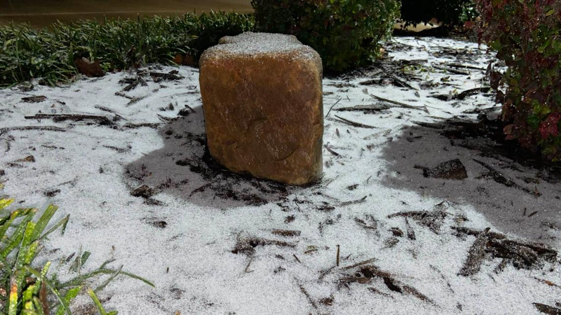
9 AM – Sleet could be seen falling in Van Zandt County Thursday morning in the Fruitvale area.

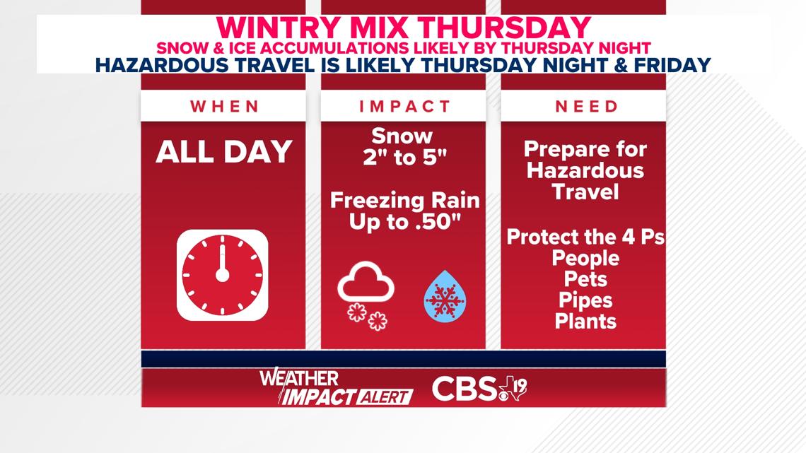
4:15AM – According to the National Weather Service, heavy mixed winter precipitation is expected to begin around midday on Thursday and last through Friday morning. Total snow accumulations between 2″-8″, mainly along and north of the I-30 corridor, and ice accumulations up to one quarter inch are expected in the warning area (pink shaded). Lesser amounts of snow and ice are expected farther south and east in the advisory area (purple shaded). Stay tuned for updates as the forecast may require adjustments to the warning and advisory areas.
WEDNESDAY, JANUARY 8
9:15AM – TxDOT Tyler says they have used more than 125,000 gallons of brine to pretreat the roadways across the East Texas region ahead of the winter storm.
5AM – A Winter Storm Warning is in effect beginning Thursday at 6AM through Friday at 12PM for the following counties:
- Camp
- Cass
- Franklin
- Gregg
- Harrison
- Marion
- Morris
- Rains
- Smith
- Titus
- Upshur
- VanZandt
- Wood

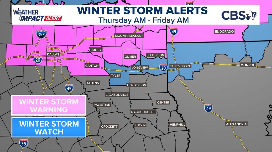
The National Weather Service is still expecting between 2″-6″ of snow accumulation and up to a 1/2″ of ice accumulation in the shaded counties (blue and pink).
TUESDAY, JANUARY 7
4:30 p.m – Here’s the latest from CBS19 Chief Meteorologist Brett Anthony:
It’s the calm before the winter storm. Speaking of the winter storm, there is a Winter Storm Watch in effect from Thursday morning until Friday morning. The storm is a little slower as it heads this way and that could lead to lighter ice and snow totals but not too far off from what our original thinking has always been. A mix of freezing rain, sleet and snow should arrive in East Texas before noon Thursday. We will then see pockets of rain, freezing rain and sleet through the afternoon. The wintry mix is expected to increase in intensity overnight into Friday morning, but a layer of very warm air aloft may result in most of the precipitation falling as rain. The tricky part will be the road surface temperatures and whether any of the rain freezes to power lines and tree limbs which cool faster than the ground. Needless to say, it’ll be touch-and-go at times at the height of the event.
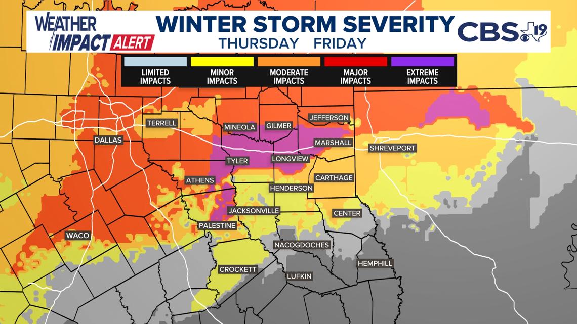
8AM – The Weather Prediction Center has upgraded their winter storm severity index for East Texas. Areas along I-20 are now in the “extreme impacts category.” This means extremely dangerous or impossible driving conditions and expansive and widespread closures are expected.

7AM – Be prepared for the threat of wintry weather across the region.
The NWS has provided the following tips as part of a Winter Storm Planning Timeline:
NOW – Have emergency supplies for your home and car; Check some and carbon monoxide detectors; Replenish fuel for car and heating sources
THE DAY BEFORE – Adjust plans; Have multiple ways to receive warnings; Bring pets indoors and ensure they have water
DURING AND AFTER – Check on neighbors and family; Properly ventilate emergency heat sources; Keep generators at least 20 feet from your home; Take it easy when shoveling
4:45 AM – The latest winter storm severity index released spells trouble for parts of Deep East Texas when it comes to freezing rain. The WSSI model shows major impacts to travel and possibly power outages over parts of Cherokee, Rusk and southeast Smith County.


4:40AM – A Winter Storm Watch has been issued beginning at 6AM Thursday, Jan. 9, through noon on Friday, Jan. 10, for the following East Texas counties:
- Camp
- Cass
- Franklin
- Gregg
- Harrison
- Hopkins
- Marion
- Morris
- Rains
- Smith
- Titus
- Upshur
- VanZandt
- Wood
The National Weather Service says the area could see heavy mixed-precipitation with total snow accumulations between 2″-6″ and ice accumulations up to 1/2″.
Roads, especially bridges and overpasses, will likely become slick and hazardous. Power outages and tree damage are likely due to ice. Travel could be nearly impossible.
MONDAY, JANUARY 6
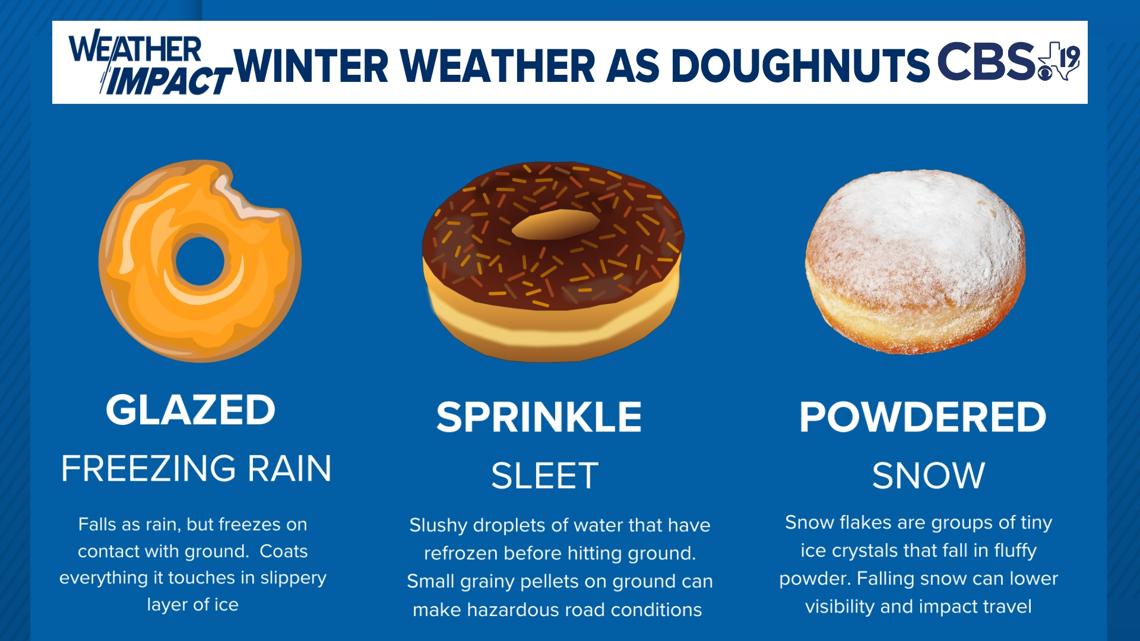
What are the differences between freezing rain, sleet and snow? We’ve got the perfect way to help you remember – with doughnuts!

7AM – The Electric Reliability Council of Texas (ERCOT) issued a Weather Watch for Jan. 6 through Jan. 10, as temperatures plummet across the state.
The grid operator said Sunday it expects conditions to be normal during the watch, but that cold weather could prompt higher electricity demand.
“ERCOT is monitoring conditions closely and will deploy all available tools to manage the grid, continuing a reliability-first approach to operations,” the organization said.
SUNDAY, JANUARY 5
1:44PM – A Tornado Watch affecting Cherokee, Harrison, Rusk, Nacogdoches, Marion and Panola counties has been canceled.
11:24AM – A Severe Thunderstorm Warning is in effect for Harrison and Marion counties until 12:30PM.
11:19AM – A Severe Thunderstorm Warning is in effect for Cherokee, Harrison, Rusk, Gregg, Shelby and Panola counties until 12:15PM.
11:09AM – A Flood Warning is in effect for Rusk, Nacogdoches, Shelby and San Augustine counties until 6PM.
11:09AM – A Flood Warning is in effect for Houston, Trinity and Angelina counties until 3PM.
10:47AM – A Tornado Watch is in effect for Cherokee, Harrison, Rusk, Sabine, Nacogdoches, Shelby, Marion, Angelina, San Augustine and Panola counties until 6:00PM.
10:30AM – A Tornado Watch is in effect for Houston and Trinity counties until 6PM.
10:25AM – A Severe Thunderstorm Warning is in effect for Cass and Marion counties until 11:30AM.
9:55AM – A Severe Thunderstorm Warning is in effect for Cass County until 10:45AM.
4:40AM – A Freeze Warning is in effect for Houston and Trinity counties until 9AM Monday.
DID YOU KNOW?
CBS19 is available live and on-demand on your favorite TV streaming device, anytime from anywhere in the U.S.
The free CBS19+ app for Year, Amazon Fire TV, Apple TV and smart TV devices features a 24/7 stream with the latest from CBS19.
In addition to the live stream, watch the latest from CBS19 on-demand, along with additional programming from our partners at TEGNA (like Verify, “Killer Cases” and “In the News”) and Locked On Sports, plus special collections from CBS19 like Under the Lights, Hooked on East Texas and CBS19 Originals.
DOWNLOAD ON ROKU
Add the free CBS19 channel by searching for CBS19 East Texas News in the Roku Channel Store on your device, or add the CBS19+ Roku channel using this link.
DOWNLOAD ON FIRE TV
Search for the free CBS19+ app in the Amazon App Store directly on your Fire TV or Fire TV Stick, or add the CBS19+ Fire TV app using this link.
DOWNLOAD ON APPLE TV
Learn more about the free CBS19+ app in the Apple TV App Store and download directly from your Apple TV device.
DOWNLOAD ON YOUR SMART TV
The CBS19+ app is also now available directly on “smart” or “connected” televisions made by Samsung, LG and Philips, as well as televisions with Android TV. Search for CBS19 East Texas News in your television’s app store to add CBS19+.
OTHER FREE WAYS TO WATCH
The CBS19+ 24/7 stream can be viewed on any desktop or mobile web browser anytime on the Watch page here on cbs19.tv.


