Live Updates: Severe Weather, Tornado Warnings And Watches In Texas, Oklahoma And Arkansas


Senior digital meteorologist Jonathan Erdman contributed to this article.
Tornado warning sirens sounded as lightning lit up the skies before dawn across parts of Texas, Oklahoma and Arkansas Wednesday morning.
(MORE: What To Expect From These Dangerous Storms)
A powerful line of severe storms is bringing dangerous winds, hail and tornadoes from the South to the East Coast. Damage is being reported across the Dallas-Fort Worth area and hundreds of thousands of people have lost power. Here’s the latest news.
(10:56 AM EST) Severe Reports, So Far

So far, over 90 reports of severe thunderstorms have been received by National Weather Service offices since late Monday night. The majority of them have been in a swath from the Dallas-Ft. Worth Metroplex into southern Oklahoma.
NWS damage surveys will be conducted later to determine the number, strength and paths of any tornadoes. It is likely both Oklahoma and Texas just had their first tornadoes of 2025 early this morning.
(10:20 AM EST) Widespread Damage In Ada, Oklahoma
Residents of Ada, Oklahoma are sharing photos of homes and other buildings torn apart overnight and early this morning. City officials are urging people to stay at home because there are “downed power lines, gas leaks and trees everywhere.”
(10:05 AM EST) The Difference Between A Tornado Watch And A Tornado Warning
During active weather, it’s critical to know the difference between watches and warnings.
A tornado watch means tornadoes are possible in the watch area or other locations nearby. A watch means you should pay close attention to weather alerts and be ready to take immediate action. Anyone in manufactured housing or vulnerable structures should consider heading to stronger shelter.
A tornado warning means it’s time to take action now – quickly move into your shelter or safe space and stay there until the warning is over.
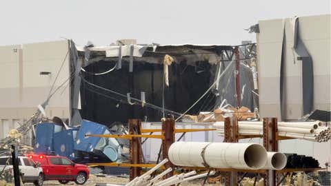
(09:52 AM EST) Warehouse Collapses In Lewisville, Texas
A warehouse for Benjamin Moore Paints is seen torn open after a suspected tornado ripped through Lewisville, Texas. Part of the warehouse collapsed and the debris buried semi-trailers and other vehicles nearby. The parking lot is covered with metal sheeting from the warehouse roof. It’s not yet clear if any workers were inside the building at the time of the collapse, but first responders are on the scene and there are no immediate reports of injuries.
(09:25 AM EST) It’s Snow, Now. Blizzard Conditions Ahead
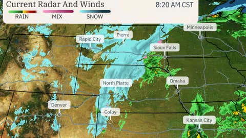
Within the past hour or so, rain has quickly changed over to wet snow from eastern Colorado and far northwestern Kansas to parts of South Dakota.
Winds are also gusting from 30 to 55 mph in this zone. Conditions are deteriorating along stretches of Interstate 70, 80 and 90 in these areas. Whiteout conditions are possible in these areas, at times.
(09:11 AM EST) Damage Reported In Southeast Oklahoma
A home is reported destroyed and several campers are overturned in Kingston County, Oklahoma. In Nida, Oklahoma, a trailer home is left destroyed, according to Johnston County Emergency Management.
Marshall County Emergency Management reports power lines down and structural damage in the county. In Durant, a house collapsed, but no injuries are reported, according to Durant Emergency Management.
(09:36 AM EST) Significant Storm Damage In Irving, Texas
Irving Police Department is warning people to avoid the intersection of North O’Connor Road and West Pioneer Drive as significant storm damage is seen in the area.
In photos posted on social media by the police department, a wall can be seen completely torn off of an apartment building and the roof is damaged.
(08:59 AM EST) Squall Line Threats Today
Today is a good example why you should take severe t-storm warnings as seriously as tornado warnings, as weather.com senior meteorologist Chris Dolce wrote.
Wind gusts capable of downing trees and knocking out power are likely within the line of severe t-storms rolling through the South. It doesn’t take a tornado to do that. A falling tree can be life threatening. And as we’ve already seen earlier this morning, tornadoes can quickly form within the line of severe t-storms. Seek shelter with any severe t-storm or tornado warning today.
(08:43 AM EST) Flights Cancelled, Power Outages In Dallas-Fort Worth
FlightAware.com reports more than 200 flights to and from Dallas-Fort Worth International Airport are cancelled as the area sees severe weather.
In North Texas, more than 200,000 customers are without power, according to PowerOutage.com. Some structures in the area have sustained damage from the storms.
(08:30 AM EST) What’s Happening Right Now
A line of severe t-storms is near the Oklahoma-Arkansas border southward into northeast Texas. Damaging t-storm winds are the main threats right now with this line, with wind gusts strong enough to down trees and knock out power.
The severe threat has ended in both Dallas-Ft. Worth and Oklahoma City, though gusty winds are persisting.

Radar image, watches and warnings as of 8:25 a.m. EST.
(08:12 am is) Tuesday fat events canceled
Today is Fat Tuesday, the traditional peak of Louisiana Mardi Gras parades. But weather is getting in the way.
Parades are officially canceled in Jefferson Parish, which is part of the greater New Orleans area.
As of Monday evening, police in New Orleans said they were watching the weather closely. Some parade times were changed, but they said cancellations could be called closer to the events. At least one was canceled.
The Weather Company’s primary journalistic mission is to report on breaking weather news, the environment and the importance of science to our lives.


