Severe Thunderstorm Warning Update | Do-not-import

Kgwx 20241229 0412 Br 05
A severe thunderstorm warning remains in effect until 10:45pm for Marion and Fayette counties. The National Weather Service has also just extended the Tornado Warning in Marion County until 10:30pm
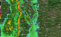
At 10:08 PM CST, severe thunderstorms were located along a line extending from 8 miles south of Cherokee to near Eldridge, moving northeast at 55 mph. Expect considerable tree damage. Damage is likely to mobile homes, roofs, and outbuildings. Locations impacted include… Hamilton, Winfield, Fayette, Haleyville, Guin, Hackleburg, Berry, Brilliant, Glen Allen, Gu- Win, Bankston, Boley Springs, Brinn, Lake Buttahatchee, Bear Creek, Twin, Tucker, Stone Wall, Wayside, and Richard Arthur Field.
A Tornado Watch remains in effect until 400 AM CST for central, northwestern and west central Alabama. For your protection move to an interior room on the lowest floor of a building. Intense thunderstorm lines can produce brief tornadoes and widespread significant wind damage. Although a tornado is not immediately likely, it is best to move to an interior room on the lowest floor of a building. These storms may cause serious injury and significant property damage.
You can join us live on TV, the free WVUA23 app, the website stream at wvua23.com and facebook live on the Richard Scott WVUA23 page. We want to have multiple ways you can reach us if a storm threatens your area.
Join us live on WVUA23 weekdays at 5 P.M. & 10 P.M. and weekends at 10 P.M. for the very latest on your news, weather and sports.
Anna DuVall
Youtube:https://www.youtube.com/c/RichardScottWeather
Twitter: RichardWVUA23
Facebook: RichardScottWVUA23


