Severe Thunderstorm Warning Update | Do-not-import

Kgwx 20241229 0309 Br 05
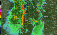
The National Weather Service in Birmingham has issued a Severe Thunderstorm Warning for Lamar County in west central Alabama, Pickens County in west central Alabama, Greene County in west central Alabama, Sumter County in west central Alabama until 10:00 PM CST.
At 9:06 PM CST, severe thunderstorms were located along a line extending from Verona to near Bent Oak, moving northeast at 55 mph. This includes 60 mph wind gusts expect damage to roofs, siding, and trees.
Locations impacted include: Vernon, Sulligent, Millport, Kennedy, Detroit, Beaverton, Blooming Grove, Lamar County Airport, Crews, Bedford, Crossville, Cody, Henson Springs, Lamar County Public Lake, Star, Pine Springs, Hightogy, and Melborne.
These storms are producing widespread wind damage across Central Mississippi. SEEK SHELTER NOW inside a sturdy structure and stay away from windows! Intense thunderstorm lines can produce brief tornadoes and widespread significant wind damage. Although a tornado is not immediately likely, it is best to move to an interior room on the lowest floor of a building. These storms may cause serious injury and significant property damage. A Tornado Watch remains in effect until 400 AM CST for northwestern and west central Alabama.
If there is a tornado warning issued for west Alabama, you can join us live on TV, the free WVUA23 app, the website stream at wvua23.com and facebook live on the Richard Scott WVUA23 page. We want to have multiple ways you can reach us if a storm threatens your area.
Join us live on WVUA23 weekdays at 5 P.M. & 10 P.M. and weekends at 10 P.M. for the very latest on your news, weather and sports.
Anna DuVall
Youtube:https://www.youtube.com/c/RichardScottWeather
Twitter: RichardWVUA23
Facebook: RichardScottWVUA23


